
GeoNet Rapid
GeoNet Rapid - Being Faster
GeoNet Rapid - Introducing SeisComP3
Over the last year we have been working on implementing a new system for GeoNet to locate earthquakes in New Zealand. Soon we will start a public beta of the new system. This post introduces the star of the new system: SeisComP3. One of the main goals of the project is to be faster at locating earthquakes. We selected SeisComP3 which was developed within the German Indonesian Tsunami Early Warning System (GITEWS) project by GeoForschungsZentrum (GFZ) Potsdam and is now maintained by Gempa. SeisComP3 is a distributed system that uses a messaging bus. This means that it can be scaled to allow processing of many seismic sites. GFZ are currently processing around nine hundred sites from around the globe in real time. Throughout testing for New Zealand SeisComP3 has proven to be very impressive and it looks like we should be able to make earthquake locations available on the web site much faster.
Locating Earthquakes - Being Faster
Being faster - easy, right? Just stop doing the slow bit. For GeoNet the slow part is that a person has to get involved. The fastest we can currently typically locate an earthquake is around ten minutes but it’s usually more like fifteen to twenty minutes. During the night it can be a real challenge – a pager beep wakes the Duty Officer from a dead sleep, they get up and boot a computer, login, bring up the seismograms, review, locate and finally post the event. Learn more about locating earthquakes in the links at the end of this page.
SeisComP3 doesn’t need manual help, it can make automatic earthquake locations. As soon as it has enough data (from ten stations) it makes a first location. As more data arrives, from more distant stations, it refines the location through an iterative process. This process is finished when the last data arrives and is processed. So how fast is it? During the recent sequence of earthquakes on 23 December 2011 in Canterbury the test version of SeisComP3 located one hundred and six earthquakes over magnitude three. On average SeisComP3 had;
- The first automatic location after two minutes.
- The final automatic location after four minutes.
Compare that to how long a manual location takes! Also, SeisComP3 doesn’t struggle to keep up. When the earthquakes are happening close together it is very hard for the Duty Officer to keep up.
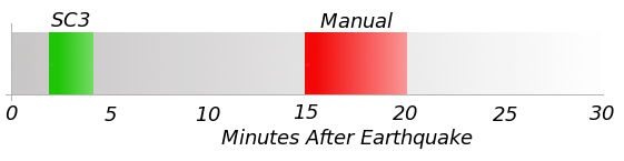
Figure 1: On 23 December 2011 (UTC) there where 106 earthquakes over magnitude 3 in the Canterbury region. On average SeisComP3 (SC3) had a first automatic location two minutes after the earthquake occurred and a final automatic location after four minutes. Compare this to the fifteen to twenty minutes it typically takes to make a manual location.
So, SeisComP3 makes earthquake locations very quickly. However, because initially it’s fully automatic it can make mistakes; things like noise, two earthquakes at the same time, or the earthquake being off shore (outside the network) can cause SeisComP3 to make mistakes. For significant events a Duty Officer will still manually review SeisComP3’s work.
We are currently working out the best way to display the earthquake information as SeisComP3 iterates the location. We’re also updating our delivery systems to handle the extra information. I’ll cover these changes in future posts.
Links
Links to information about locating earthquakes.
- How is an earthquake’s location determined? - a great video with one of GeoNet’s own Duty Officers explaining how earthquakes are located.
- How are earthquakes located? [pdf] - one of the many excellent education resources available from IRIS.
- Earthquakes - more about earthquakes in New Zealand at Te Ara.
- Hypocentre derivation and earthquake - technical information about the way GeoNet currently located earthquakes.